Coal Mining's Impact on Water and Land
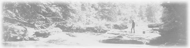
The greatest contributor to both impaired water quality and land degradation in the Stonycreek watershed is coal mining that occurred before 1977. It has caused—and continues to cause—low pH and excessive quantities of toxic metals in streams. It is also responsible for the watershed's barren lands. How did this happen?


Figures 17. Reitz # 4 AMD on Dark Shade Creek in Central City, Pennsylvania, is the worst AMD discharge in the Stonycreek watershed, according to DEP's 2003 Watershed Restoration Action Strategy for the Stonycreek River and Little Conemaugh River Watersheds. Rising up from a deep mine that closed in 1957 (left photo, Reitz # 4 source), this is a high volume discharge, averaging 2,250 gallons per minute (right photo, discharge into Dark Shade Creek), and is very acidic, with a pH of 2.3. To make matters worse, its aluminum load exceeds that of any other AMD in the Stonycreek watershed. Treating the Reitz # 4 discharge has been a topic of discussion since the early 1990s, but because it is located in the heart of Central City, creating a passive treatment system of sufficient acreage to do the job seems unlikely. One treatment possibility that has been discussed is capturing and piping the discharge waters to some other location for treatment. Photo credits: Melissa Reckner, 2013.


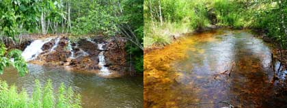
After underground coal mines close, surface water continues to infiltrate them. The mine pool builds up, seeking release wherever it can—through mine portals, ventilation shafts, or natural channels that offer the least resistance. The elements that water comes in contact with underground (e.g., iron and sulfur in the form of pyrite, as well as aluminum and manganese) will also be present when that water is discharged, along with compounds created by chemical reactions like the combining of oxygen and sulfate ions to create sulfuric acid. In addition, the combination of iron, water and oxygen forms ferric hydroxide, commonly known as "Yellow Boy." Almost all of these chemical reactions make the water very acidic (it lowers the pH), destroying the ability of the waterway to support fish and some plant life. These harmful discharges are commonly referred to as abandoned mine drainage, or AMD.


Figure 18. Poorly reclaimed surface mine area in the upper portion of Paint Creek watershed, with discharge evident on the right. Note how barren the land is, much of it not supporting significant vegetation cover of any sort. Photo credit: Tom Clark, Paint Creek Restoration Plan, 2005.

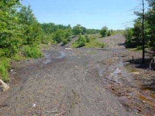
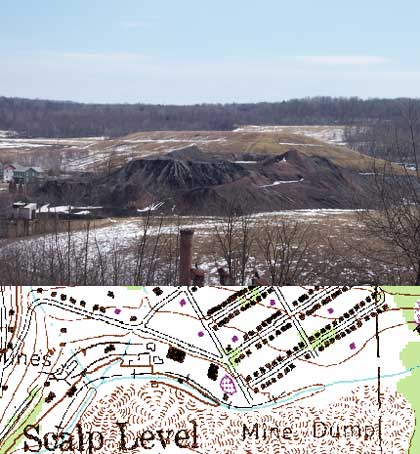
Surface mines, which by the 1950s were the dominant mining method in the Stonycreek, also contribute to AMD. They are responsible for barren areas called abandoned mine lands (AML). In surface mining, vegetation and overburden are set aside and the coal is removed. When restored properly, overburden is replaced, the land is restored to original contours, topsoil is laid down, and suitable vegetation cover is reestablished. This prevents potential contaminants from being exposed to air or water, and minimizes erosion. Unreclaimed or poorly reclaimed surface mines and coal refuse piles don't sustain productive plant life, making the sites subject to erosion and increasing sediment load in nearby streams. They are also an important source of AMD because they contain the same contaminants that are present in mine pools.


Figure 19. DEP defines abandoned mine lands (AML) as problem sites caused by past coal mining that adversely affect health, safety or the environment. They include both flooded and dry surface mines, mine pools in deep mines, spoils areas, waste piles, settling basins and areas at risk of subsidence due to coal mining. Map credit: Mary Lavine

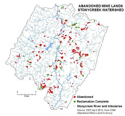
Today, slightly less than one percent of the Stonycreek watershed is classified as mining or "other disturbed surface" (e.g., sand and gravel pits). While most of the AML is unreclaimed surface mines, it also includes waste coal piles. About 80% of the watershed's AML acreage, totally nearly 2300 acres, is still un-reclaimed. AML sites are broadly distributed across the watershed, many in close proximity to streams.


Figure 20. This coal refuse pile (aka boney pile) at Mine 40 is the principal AMD pollution source on Little Paint Creek. Nearby homes give a sense of how the pile dominates the community's landscape. This refuse pile accounts for about 69% of the acid loading, 95% of the iron loading, 60% of the manganese loading, and 90% of the aluminum loading in Little Paint, and thus contributes to AMD problems in lower Paint Creek and the lower Stonycreek River as well.

The accompanying map section from a 1964 USGS quadrangle map shows how far the boney pile used to extend along Little Paint Creek, and how close it was (and still is) to the stream.

Two sections of this refuse pile were removed a decade ago and the waste coal was burned at the Ebensburg Cogeneration plant. The residual alkaline ash was transported back to the sites and was used in the reclamation project there, visible in the background. Now vegetated and stable, those two sections have minimal impact on the stream, but the same clearly cannot be said for the section that remains.

Not all refuse piles are as amenable to reclamation as is this one. Along lower Paint Creek, a huge coal refuse pile from Mine 37 lies adjacent to the stream, but its comparative inaccessibility and estimated lower BTU value make its reclamation commercially unlikely.

Data source: Map section, USGS Quadrangle map, Geistown, 1964. Tom Clark, Paint Creek Restoration Plan, 2005. Photo credit: Mary Lavine.


Back to Top


Copyright ©2008 Stonycreek Quemahoning Initiative
Stonycreek-Quemahoning Initiative is a 501(c)(3) and a supporting organization of Conemaugh Valley Conservancy
Site Designed by Hurst Media Works, KH2 Design, FisherWorks Consulting and Recharge Web Design